Manage Your Projects
in One Model
6DPlanner extends BIM with new perspectives like time (4D), quantities (5D) and life cycle (6D). This will help you focus more on project's future, manage your next steps and optimize your path to success. With this you can answer questions like "how" and "when" and what "impact" your project has.


All Aspects Together in One Model
Project Execution Model
When all project aspecs are together, projects can move from inefficient sequential processes to more efficient concurrent processes.
1D
Goals
Define project goals, tasks, risks, ideas and requirements with
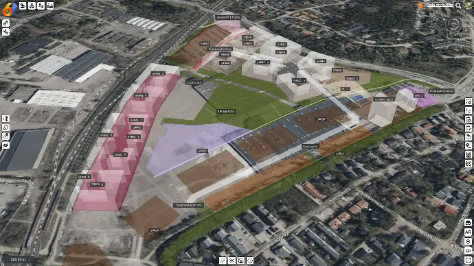
Spatial Management
2D
Scope
Manage project scope with location and linked to information with
Spatial Planning
3D
Solutions
Lead projects visually with all information combined together with
Data Fusion
5D
Quantities
Estimate and manage quantities, materials, resources and costs with
5D Estimation
6D
Life Cycle
Manage project life cycle impact like operation and sustainability with
6D Life Cycle Modeling
All Information Together in One Model
Project Information Model
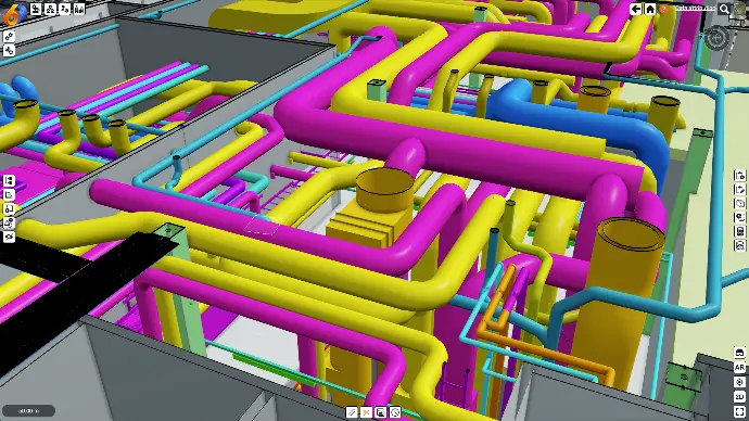
BIM
IFC 2x3 to 4.3, LandXML, Inframodel
CAD*
DWG, DGN, DXF
3D
Generic 3D model formats
Sketch
Rapidly model elements, lines, areas and volumes with 3D libraries
Open Worlds
Global datasets like terrain, maps, satellite images, 3d buildings and Google Photorealistic 3D Tiles
GIS
Raster maps (WMS, GeoTIFF)
Vector features (WMS, GeoJSON)
City Models
CityGML, CityJSON, 3DTiles, I3S

Reality Capture
Point clouds, photogrammetry, survey data, as-built data

Documents
Files and external http links with location
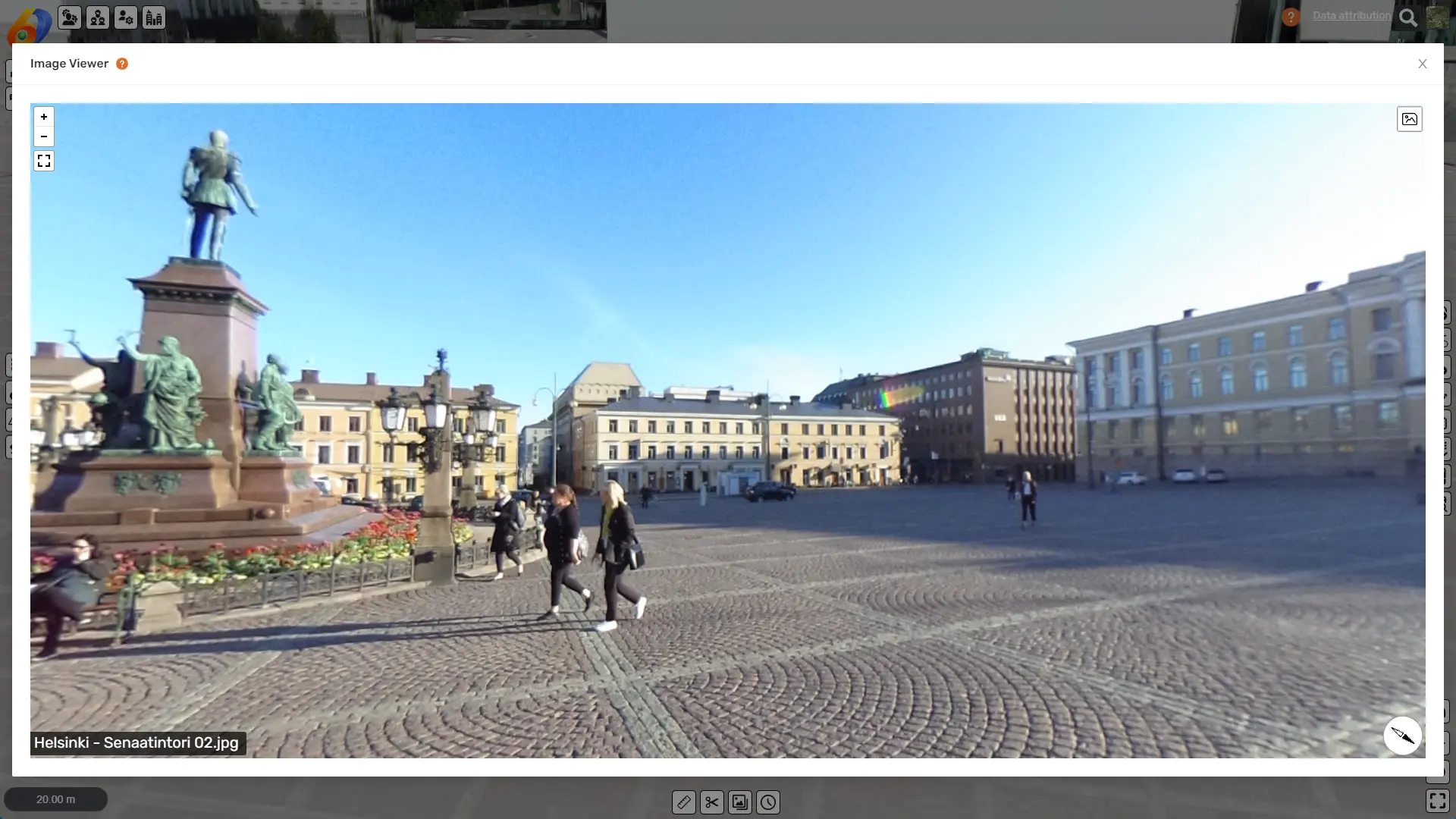
Photos
Both normal photos and 360 photos with integrated 360 pohoto viewer
Schedules
MS Project, Primavera and Excel import and export
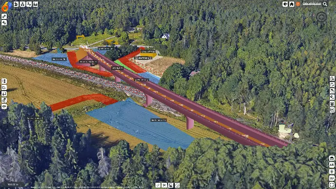
Site Plans
Work areas, storage areas, logistics routes, security fences, traffic routes, office, parking, machinery, ...
* Coming soon
Increase your team productivity
with Spatial Coordination
Replace old paper maps, hand drawings, separate scheduling and task management tools, spreadsheet calculations and document management systems with integrated and easy to use 6D Project Management.
Access and maintain up-to-date project situation and information in one place, in one app, in one view, in one user interface and in one unified easy to learn and use user experience.
You can apply 6D Project Management in any life cycle phase like city planning, design planning, construction planning, maintenance planning.
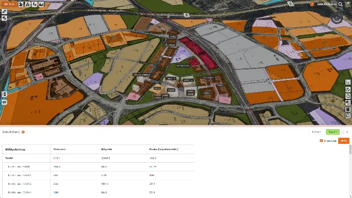
Spatial Planning
Sketch project contents quickly on top of any project information or existing situation like Open Worlds
Plan project even before project start without any BIM models. You can import BIM and other models later in the project when they are needed.
Spatial Management
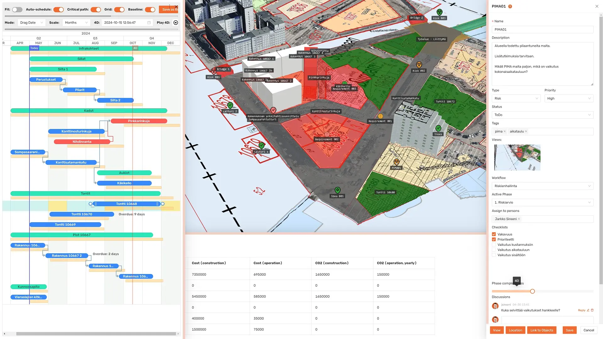
Manage project goals, requirements, ideas, tasks and risks with location and linked information.
Save time when information is automatically avaiable when action is taken under work. This eliminates time wasted in searching information from multiple places multiple times.

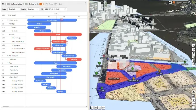
Spatial Scheduling
Plan and optimize project execution with a 4D Gantt with connection between project taks and information.
Optimize sequencing and phasing , eliminate time - location conflicts, and minimize scheduling risks.
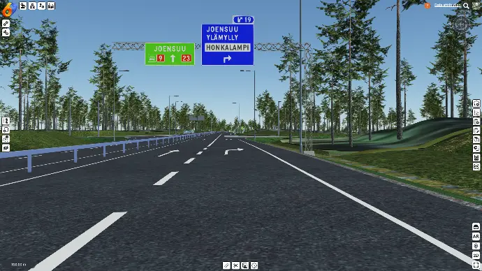
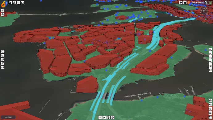
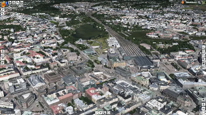
See your projects in their real surroundings
with Open Worlds
Traditional BIM tools typically focus only on BIM without project surroundings. 6DPlanner brings BIM into project's real surroundings in real world locations, which helps for example:
Make project visualizations look more realistic
Understand project scale and distances better
Ensure project structures match physical world in XYZ
Analyze project impact to its surroundings (shadows, ...)
Analyze project's fit into cityscape or landscape (visibility, aesthetics, ...)
Analyze views from the project to surroundings (apartment window views, ...)
Plan construction site arrangements and logistics routes
6DPlanner includes several ready to use global 3D datasets that can be used as project surroundings. We have for example terrain, satellite imagery, maps ja 3d buildings for the whole earth. We have also integrated Google Photorealistic 3D Tiles (famous from Google Earth) which covers over 2500 cities around the globe. You can also use local citie's city models, photogrammetry and point clouds to bring in the existing project surroundings.
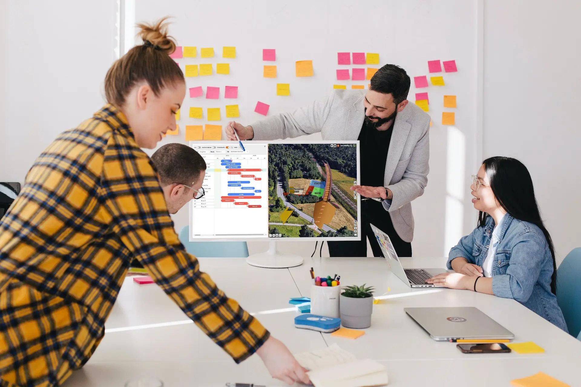
Embrace co-development and teamworking
with Open Collaboration
Share
Share projects to anyone, across organization borders, without limits. Our licenses include unlimited users, so you can invite anyone to participate project.
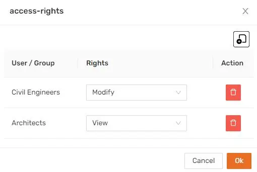
Manage access rights with user groups and go up to model or data source level.
Brainstorm
Sketch ideas into project model. Test alternatives and analyze impact together with project information.
Manage ideas, tasks and document decisions directly into project model as topics. Classify with status, tags and manage completeness.
Communicate
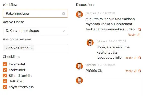
Forget emails and social chats. Comment and discuss inside project model linked to topics, location and information. Never loose important information and find discussion easily based on location and topic.
Build quality inside processes
with Action Workflows
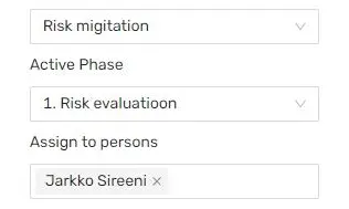
Workfows
Assign customizable workflows to project actions and automate approval, quality assurance and task rotation processes.
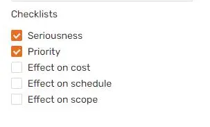
Checklists
Ensure quality by adding checklists to project actions. This way all required matters will be checked and tasks will be completed fully.
Reporting
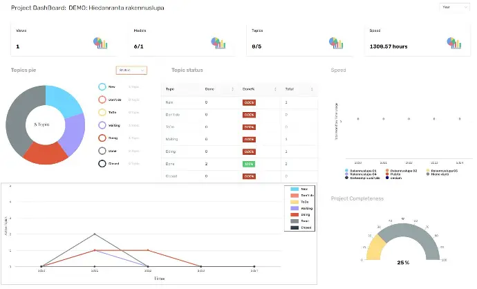
Automatic reports and dashboards tells you instantly project status and saves your time in reporting to your customers.
Engage public to participate and love your project
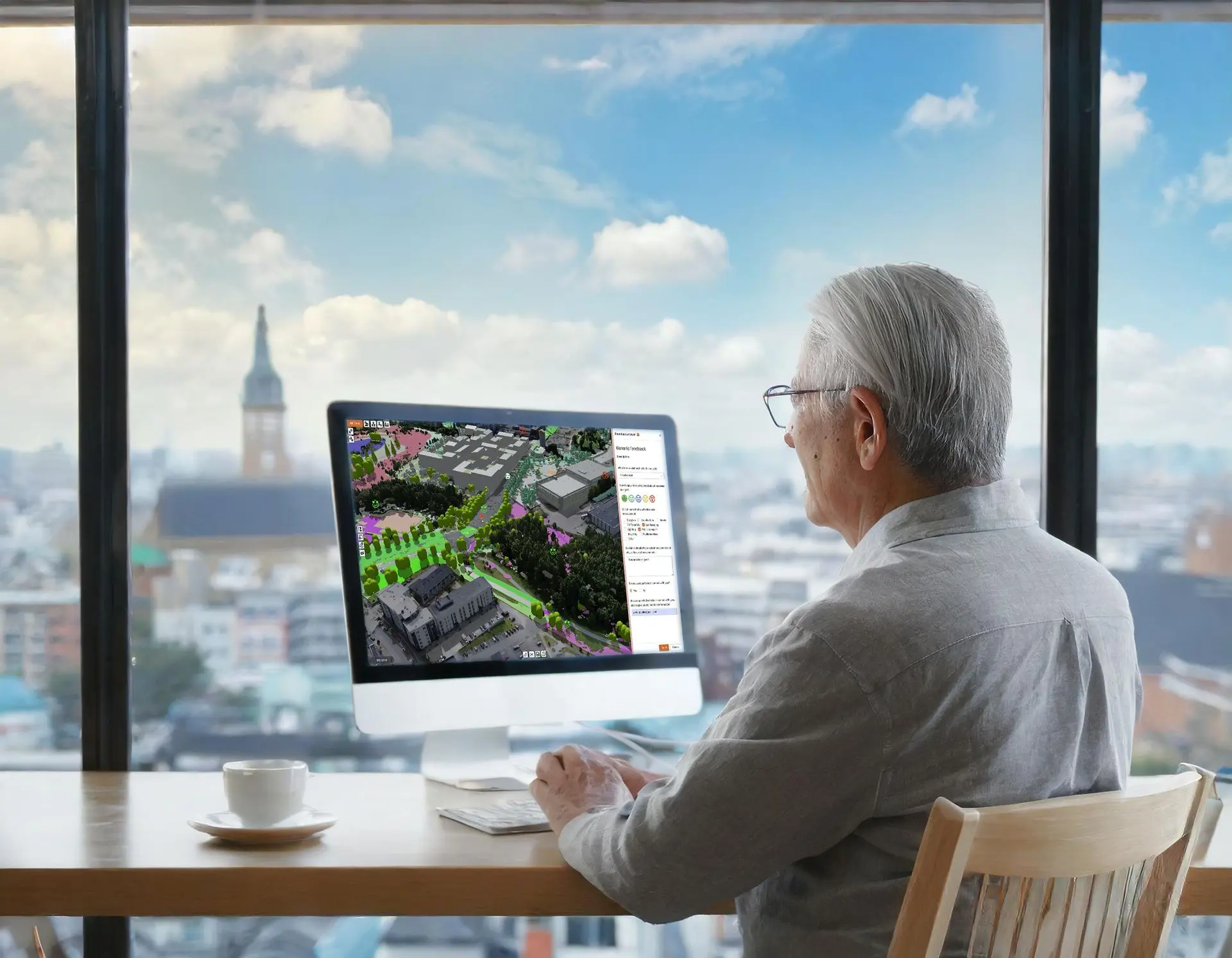
with Open Participation
Make internactive and realistic presentations with BIM and Open Worlds, anywhere, anytime, with any device, with always up-to-date project infromation.
Enagage and participate citizens, stakeholders and decision makers by publishing models on-line. Collect structured feedback with customizable feedback forms. Feedback always have location so its easier to see feedback target.
You can also connect feedback into Decidim platform, which is a widely used open source citizen participatikon platform.
Ensure predictable and optimized project execution
with 6D Execution Planning
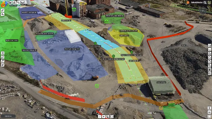
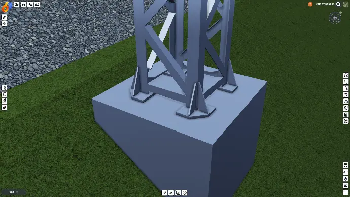
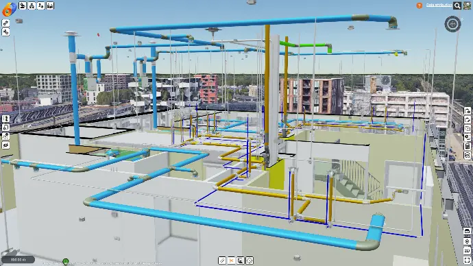
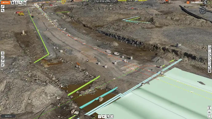
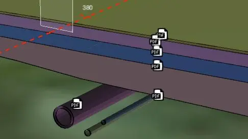
3D Site Planning
BIM doesn't tell you how you are going to construct your project. 6DPlanner allows you to model site plans as simple to use Sketch objects.
You can make site plans on top of any project information, for example site photogrammetry or point clouds. You can model work areas, storages, logistics routes, space reservations, security fences, site facilities and even place 3d models of construciton machinery to check how they will fit to move around.
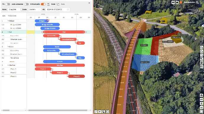
4D Scheduling
Optimize sequencing and phasing , eliminate time - location conflicts, and minimize scheduling risks.
You can schedule all data types so you are not limited to only BIM models. You can for example document site history as 6D Digital Twin using point couds and photogrammetry.
4D Gantt keeps schedule tasks separate from project information. Smart linking uses Query rules to maintain data links when models change.
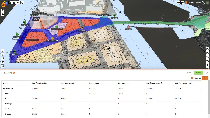
5D Estimation
Calculate quantities from BIM models or from your own custom attributes, for example materials, resources, costs, or whatever you need in your project.
4D Calculation will take time perspective into account which enables you to manage cumulative effects like Cost and CO2 accumulation and material flows in the project.
Integrated Spreadsheet will allow you do to your own calculations, for example cost estimation with your own price lists. It also eliminates time wasted to export data to external tools and updates calculations up-to-date when project models change.
6D Life Cycle Modeling
Add life cycle information to your project models. Manage for example project CO2 balance by calculating totals from each project elements.
Combined with 4D Scheduling you can manage life cycle management, for example maintenance plans and maintenance budgets.
You can even model life cycle of whole cities and claculate CO2 balance in city level. With 6DPlanner you can make true 6D Digital Twins of your projects or cities.
Site - Office Workflows
Access project information anywhere, anytime with any device. Exchange information between site and office using mobile devices. Discuss about topics, approve taks as done, ensure tasks are made correclty with checklists.
Information access on-site is fast and instant with automatic GPS positioning.
Digital handover
as 6D Digital Twins
You can deliver projects as 6D Digital Twins by giving your customer access to the 6DPlanner project. Customer can take over the ownership and continue from where you left. You can also make copies of your project to clean up the delivery model.
All infromation in the 6D Digital Twin is easily accessible to anyone who you or your customer gives access to. For example downloading model data can be done directly from the model view from model Data tree. This way 6D Digital Twin becomes infromation sharing platform for next phases in project life cycle.
BIM Models
Combine all latest updated BIM models and other information into 6D Digital Twin delivery model.
As-Built Models
Combine all as-built measurements, also those from under ground, which cannot be measured any more once constructed.
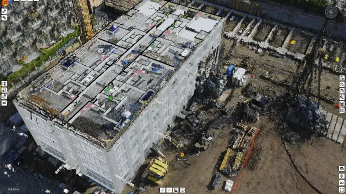
Site History
As-built measurements can have a timestamp when they were created and this can be linked to 4D Gantt to visualize and manage site history, what was constructed, when and where.
Service Plans
Define service tasks and schedules to project. Attach custom information like costs, resources, work amounts. Attach also service documents with location to make them accessible next to models.
Why choose 6DPlanner?
No Limitations
All-In-One
Stop switching between multiple tools with different user interfaces and logic.
We include all tools and unified user experience under one license. No extra modules, no extra payments, no mutiple tools any moe.
Flexible Licensing
Stop paying high prices for capacity that is not in use.
Our pricing is based on storage. This will scale up with your project volumes. You pay only little in the begining and only little more when your usage grows.
Easy to Learn
Our user experience is simple but powerful, modern and easy to use.
Anyone can learn how to use 6DPlanner. We will soon have on-line courses for users to self learn when best suited and have time.
Unlimited users
Enable all users to get access to BIM and its benefits.
We don't limit amount of users. You can invite anyone to participate your project without exra license bureauracy or extra payments.
Unlimited size datasets
Our technology is built to handle unlimited size datasets. We have done massively large projects with hundreds of BIM model files, multi-gigabyte datasets, billions of point point clouds, and all open in seconds and works even on mobile devices.
Unlimited projects
Our Enterprise license allows you to make as many projects you need. You can use your license to deliver projects to your customer, and then give your customer access to continue from where you left. We don't limit how you share your projects.
Suitable for Anything
All disciplines
6DPlanner manages all built environment disciplines together, for example city plans, architecture, structures, MEP / HVAC, steets, road, rail, bridges, tunnels, structures, networks, utilities, landscaping, traffic guidance, lighting, +++.
Anywhere, anytime, any device
6DPlanner is a cloud based solution that works completley inside any browsers. It can be used by anyone, anywhere, at anytime. Users will always have same tools, latest version, and there is no need to install any apps.
All scales
Projects are in many scales. 6DPlanner manages project data in all scales; global, national, regional, city, city area and up to single city blocks or buildings, and still handles all details from global scale up to single bolts and screws.
For Anyone
Anyone can learn and use 6DPlanner instantly. User interaface has been designed to be intuitive and easy to use. Navigation follows generic map app navigation styles which most users are already used to.
All project types
6DPlanner manages all kinds of project types, for example city planning, architecture, infrastructure, transportation, environment, industrial, energy, natural resources, logistics, real-estate, or any combination of theseFast access to information
6DPlanner gives you access to data almost instantly, in seconds. Even largest projects with gigabytes of BIM, GIS, city models, point clouds and other data opens in seconds, even on mobile devices.All life cycle phases
When cities and areas develop they are built in phases. 6DPlanner manages all life cycle phases, same time, in same model, with time perspective. You can manage planning, design, construction, operations and maintenance together.In your own language
6DPlanner is available in your native local languages, for example in English, Finnish, French, German, Italian, Spanish and Swedish. We will add new languages while we expand in global markets.Awarded by the Industry
6DPlanner has won several international innovation competitions and industry awards, which makes 6DPlanner a leader in innovation and the best solution in the market.
Urbansense
2020
AR for City Planning using 5G networks
UIA HOPE
2020
Air quality digital twin for city planning
AI4CITIES
2021
Reduce traffic CO2 emissions with AI
B.Green
2021
Green infrastructure mapping in cities
WDBE
2022
Winner of "The Best use of open standards"
SPOTTED
2023
Vegetation monitoring during construction
HELSINKI
2025
City Digital Twin Platform
Trusted by the Leaders


Loved by the Users
“Pity this has not been available earlier”
“I am in love with this solution”
“Useful for many application areas”
“We are very satisfied in pilot project results”
“Highest scores in our innovation competition”
“Absolutely brilliant in its ideology”
“Wonderful!”
"Best and easiest to use city model platform"
“Best in cost and quality in our city's digital twin plaform selection”
“This has been my dream since 1990’s”
“I like it because it actually works”
“Very impressive”
“Augmented reality on mobile browser is very promising!”
“Looks very suitable for our city needs”
“Looks much better than competing solutions”
Made by Experts to Experts
Global team
Experts in the team with diverse backgrounds
Years of total experience in the team
Projects in the system
Users in the system
Pricing that Fits Everyone
We believe BIM tools should be available to everyone and that is the only way to get full benefits. Therefore we don't limit amount of users. You can invite anyone to collaborate with you even across organization boundaries. This allows you to skip time and money consuming licensing bureaucracy!
We also believe that tools should be easily available even with small budgets. Therefore our licensing is based on usage (storage). This allows you to start with small cost and pay more only if your usage grows. This wau we can grow together!
Get Started Right Away
Demo
We show you a quick demo based on your wishes and use cases
Trial
We will give you a quick training and a free trial to test the solution yourself
Buy
Once you are happy with the trial you can buy licenses based on your needs
Support
Training and support are included so you always get help when needed